

.

.

Main photo gallerys are below Information.
GEEVESTON
Tahune Airwalk & Mt Hartz
SMALL PHOTO & INFORMATION PAGE
GEEVESTON is a forestry town in south eastern Tasmania. It is located south west of Huonville. It has some accommodation and a number of facilities. There are a number of attractions near Geeveston. The famous TAHUNE AIRWALK is west of Geeveston.
From Geeveston you are 30 minutes from HUONVILLE and 60 minutes from HOBART, SOUTHPORT and KETTERING the gateway to BRUNY ISLAND.
You are 90 minutes from COCKLE CREEK and the entrance to the SOUTH WEST National Park. Nearby places are described in the HUON VALLEY REGION.
View Region Huon Valley in a larger map
FACILITES: There are shops, a cafe and a petrol pump at Geeveston. There is some accommodation at GEEVESTON.
TOURIST information is located at Church Street, Geeveston. The telephone is (03) 6297 1836
-
CAMBRIDGE HOUSE BB: Telephone (03) 6297 1561 or contact www.cambridgehouse.com.au
-
FOREST & HERITAGE CENTER: Telephone (03) 6297 1821
-
HARTZ MOUNTAINS National Park: (03) 6264 8460
-
TAHUNE AIR WALK: Telephone (03) 6297 0068 or contact www.tahuneairwalk.com.au
SIGHTS: Geeveston is the last significant town for shopping in the south west, as there are only hamlets south of Geeveston. The town calls itself a forest town, as logging has been very important in the area, since the mid 19th Century. There is a FOREST & HERITAGE Centre in the town.
Geeveston is a good place to stay for touring the south west of Tasmania. Two hours drive to the south is COCKLE CREEK, the most southerly point in Tasmania and the starting point for intrepid bush walkers walking on the World Heritage SOUTH COAST TRACK. From Geeveston you can easily drive to the TAHUNE AIR WALK and the Mt HARTZ NATIONAL PARK.
SOUTHPORT with its HASTINGS CAVE is an hour to the south. There is a beautiful road along the Huon River, which begins just south of Geeveston at Surges Bay. This takes you the long way to DOVER, but the views of the Huon are really worth seeing.
ROUTE: The A6 Huon Highway from Huonville is the only way in and out of the South West.
To LARGER GEEVESTON PHOTOS
- Geeveston
- Tahune
- Mt Hartz
- Mt Hartz 2
1/ Geeveston is a historic town south of Huonville. It has all the commercial facilities of a small town. It was founded as a wood cutting town and prides itself on its ancient, logging industry. This image shows the lovely, historic church of Geeveston.

2/ As you enter Geeveston from the north you pass between these large logs. They proudly state to the visitor that Geeveston is a logging town.
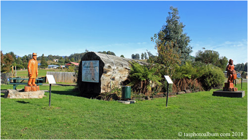
3/ This is the monument to the loggers of Geeveston. This log is 58 metres long and 5.7 metres girth. It shows you the size of the trees that once used to proliferate this part of Tasmania. Sadly now, most of these giants are gone. Flanking it are two wood sculptures. They celebrate two local personalities. There are a large number of these sculptures in the town centre area.

5/ This is the community hall and childrens park of Geeveston. This park has paths and traffic lights to teach children how to ride safely.

6/ This is the old town hall of Geeveston. It was the largest building of its type that I saw south of Hobart. You can purchase tickets for the Tahune Air Walk here. On the left you can see another one of the many sculptures of Geeveston.
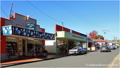
7/ This is the town centre of Geeveston. Geeveston has cafes and every facility of a small town.

8/ This is one of the many wood sculptures of Geeveston.

9/ Cambridge House was the original residence of Osbourne and Eliza Geeves, the founders of Geeveston. It is now an attractive BB.

10/ At the edge of the children's park is an area where you can watch for platypuses.

11/ Geeveston has a large, primary school. I was particularly impressed by the lovely autumn colours that I saw there in the late afternoon.

12/ This was the view out of my hotel window of the peace Huon River in the early morning. On the distant shore is a salmon farm, as the Huon is a major producer of farmed salmon.

13/ On the southern approach to Geeveston you pass by this interesting old store house. It was probably once used to store apples.

14/ The Kermandie Hotel is at Port Huon, which is just north of Geeveston. It is dominated by this fine old hotel. I was very impressed by both the cuisine and the accommodation.

15/ The Port Huon marina is an important mooring point for boats on the Huon River.

1/ The Tahune Air Walk is located west of Geeveston in south eastern Tasmania. Visitors can access a 600 metre walkway that is between 20 to 37 metres above the ground. This gives you access to the view from the top of the canopy, a view usually seen only by the birds. There are also other ground level walks, rafting and even a hang gliding course at Tahune.

2/ This is the visitor centre at Tahune. This complex includes a large cafe, a tourist shop, accommodation and even a theatre.

3/ This map at the visitor centre shows you what is available at Tahune. From the visitor centre you cross the Huon River and climb a small hill to access the air walk, which is marked in red on this map. Note that the air walk is rated as wheel chair friendly. For the more adventurous there is the Swinging Bridges walk, plus rafting, kayaks and even a hang gliding course.

4/ When you leave the visitor centre you cross the peaceful Huon River to access the air walk.

5/ This is the view from the bridge of the Huon River at the visitor centre.
6/ You must now climb a small hill to access the air walk. However, the pathways and stairs are of first rate quality. There is also a mini bus to bring up wheel chairs to the start of the air walk.

7/ On the approach to the air walk you meet the first of many giant trees. This is a giant, stringy bark eucalyptus tree.

8/ This is the ground level view of this tree to the canopy above. I estimated that this stringy bark tree was about 70 metres high.

9/ This is the entrance to the air walk. From this point onwards you are 20 to 37 metres above the ground.

10/ From the air walk you get to see a much closer view of the tops of the trees.

11/ The air walk even includes areas, where wheel chairs can be turned around.

12/ This is the view down towards the ground. This view is normally only seen by birds.

13/ This stump is the wishing tree. Visitors throw coins onto the this stump and if they land there then they can make a wish. The money is later collected for a charity.

14/ This image shows how the air walk wends its way between the tops of the trees.

15/ This image looks to the east to the dense forest that constitutes the Picton Valley.

16/ This is the view to the east of the air walk towards the Huon River. Note the extreme variety of trees that you can see.

17/ This is the last section of the air walk, which points out towards the Huon River. It looks down the Huon River to the point, where the Picton river diverges from it. Beyond is the pristine wilderness of the South West National Park. The South West is only for parties of the experienced of bush walkers.

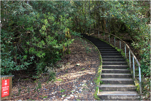
18/ We now exited the air walk to access the Huon Pine walk. These two lovely manferns flank the stairway.

19/ This is the shelter and cooking oven at the start of the short Huon Pine walk. The lady is walking towards the start of this walk. This short walk follows the Huon River and shows you the many types of trees that grow close to the river.
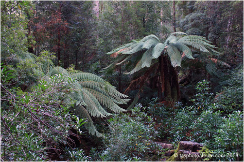
20/ These are manferns. They are an ancient plant that are common to the rainforests of Tasmania.

21/ This one of the many large trees that you see on the Huon Pine walk. It is a stringy bark eucalyptus tree. These trees are often covered with moss at their lower levels.

22/ This is the awesome view up towards the canopy of of this giant stringy bark.
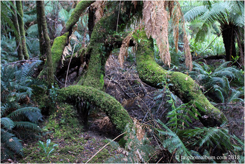
23/ The vegetation at ground level, also presents many interesting sights. The base of this tree is covered with these interesting growths of mosses.

24/ This image looks across the Huon River. It was taken at the end of the Huon Pine walk near where the hang gliders cross the river.

25/ This image shows the wide variety of vegetation that you see at ground level.
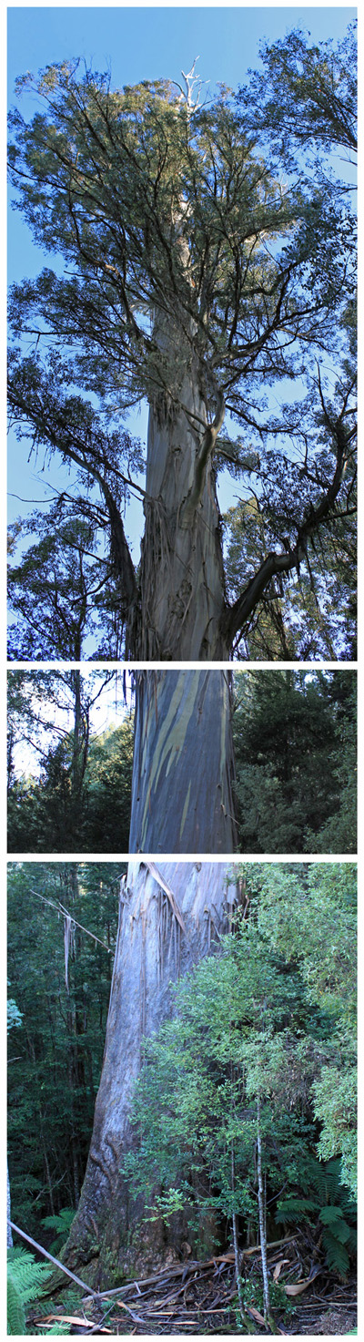
26/ About 10 kilometres east of the Tahune Air Walk is a short road to the "Big Tree". This is a massive 87 metre tall eucalyptus tree. It has a girth of 17 metres and is rated as possibly the largest by wood volume of its type in Tasmania. It is a rare survivor of the thousands of other forest giants that once grew in this forest. For some reason it was rejected by the loggers of the past for which we are now eternally grateful. I decided to join 3 photos together, so that you can better appreciate the full spectacle of this magnificent living thing.

1/ Mt Hartz is in the extreme south east of Tasmania west of Geeveston. There is a boardwalks to Ladies Tarn, which is close to Mt Hartz. The final track to the summit of Mt Hartz is rough, but easy to follow. There is also a rough track to nearby Mt Snowy. This gallery shows photos made on a visit on Mt Hartz in 2015. Mt Hartz is the peak on the left and the Backbone Peak is on the right.

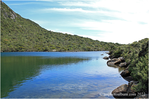
2/ The first land mark reached is Lake Esperance. This is a lovely lake at the bottom of the Backbone Peak, which is on the right.

3/ This is the view of Lake Esperance and the cliffs of the Backbone Peak.

4/ This image show the rough track to Mt Hartz beyond Ladies Tarn.

7/ This image shows Hartz Lake on the left and a large outcrop on the right. The track to the summit is on the right.

8/ This is the view from the near the summit of Mt Hartz. It looks down on Lake Hartz.

9/ This is the summit of Mt Hartz. It is 1254 metres high. On a clear day you can see many of the rugged peaks of south western Tasmania.

10/ This is the view from the summit of Mt Hartz to the north west. Lake Hartz is to the right.

11/ This is the view to the north east of the Mt Hartz summit. The large tarn is Emily Tarn and the smaller is Arthur Tarn. The track that you can see on the right leads to Mt Snowy.

12/ I was most fortunate to get this photo of a wedge tail eagle that swooped past. There are still some extant in the Hartz Mountains National Park.
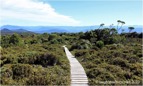
1/ This image looks to the north and shows the boardwalk of the Hartz Peak Trail. Just beyond this image is the car park and shelter. This boardwalk stretches as far as Ladies Tarn. However, from beyond Ladies Tarn the ascend of Mt Hartz is hard.

2/ The Hartz Peak Trail wends its way to the south. To the west are a series of rugged peaks.

3/ The first major attraction is Lake Esperance. There is a viewing platform and seats at this point.

4/ Across Lake Esperance I could see a plethora of trees. I found this grove of pencil pines enchanting.

5/ This image shows our party advancing to the south on the boardwalk. The peak to the right is Mt Hartz, while the peak to the left is Mt Snowy.

6/ We passed a number of lovely tarns on our way. In the distance you can see Mt Snowy.

7/ This image looks towards the east. The landscape drops abruptly in this direction.

8/ To the west are the many heights of the Hartz Mountain Range.

9/ From this point you could see far to the east and all the way to the Derwent River Estuary.
10/ This is Ladies Tarn. At this point the easy boardwalk finished.

11/ This image shows the peaks of the Hartz Mountain Range that look down on Ladies Tarn.

12/ From this point we began the 260 metre ascend of Hartz Peak. Its summit is 1240 metres high and the views from the summit are spectacular.

