

.

.


Main photo gallerys are below information.
LAKE BURBURY
Mt Jukes, Mt Huxley, Mt Owen, Mt Sedgwick Walford Peak & Nelson Falls
SMALL PHOTO & INFORMATION PAGE
LAKE BURBURY is a very large artificial lake in south western Tasmania, east of Queenstown. It is a favorite boating and fishing area for Tasmanian. The lake is surrounded by stunningly, beautiful mountains and, best of all, it is within commuting distance of Queenstown. This page will show you Lake Burbury, plus a number of the mountain attractions near the lake.
There is only a caravan park on Lake Burbury, so all other facilities relate to Queenstown. It is also important to note that Queenstown is a very isolated place. It is 40 minutes from ZEEHAN and STRAHAN, a longer 60 minutes from ROSEBERY and a massive 2 hours from HOBART.
The only place near Lake Burbury is QUEENSTOWN, but other places in the West Coast Region are described in my WEST COAST REGION page.
View West Coast in a larger map
FACILITIES: There is a caravan park on the eastern shore of Lake Burbury, however all other facilities must be accessed from Queenstown. At Queenstown there are shops, cafes, petrol stations, vehicle repairs and a full range of businesses. There is some accommodation in QUEENSTOWN.
TOURIST information is at the Gallery Museum, 1 Driffield Street, Queenstown.
SIGHTS: You can camp at a number of places around Lake Burbury and you can stay at the caravan park on the eastern shore. Accessing the mountains described below is for experienced bush walkers.
ROUTE: LAKE BURBURY is on the road back to Hobart, which is the A10 Lyell Highway. It is east of Queenstown.
NELSON FALLS are further east of Lake Burbury. They are within an easy walk of the A10 Lyell Highway.
LAKE PLIMSOLL is accessed from B28 Anthony Road, which diverges from the Zeehan Highway. There is a track south of Lake Plimsoll that goes all the way to Lake Spicer, but this track is for experienced bush walkers only.
To LARGER BURBURY PHOTOS
- LAKE BURBURY
- Nelson
- Jukes
- Huxley
- Owen
- Sedgwick
- Walford

1/ Lake Burbury is a huge, artificial lake in far western Tasmania. It is east of Queenstown. Lake Burbury is surrounded by mountains, which give beautiful views in all directions. The lake is used for fishing, boating and kayaking. This view looks towards the north.

2/ Lake Burbury sits astride the A10 Lyell Highway. This road connects Queenstown with Hobart and the rest of Tasmania. This view shows the western edge of Lake Burbury. Beyond this mountain is Queenstown.

3/ This view shows the western edge of Lake Burbury looking towards the north.

4/ This photo shows the causeway that divides Lake Burbury into a northern and a southern half. To the east of Lake Burbury were some very impressive mountains like Mt Owen and Mt Lyell.

5/ Lake Burbury gives off a range of colors. This photo looks towards the south and was taken in the very late afternoon. The atmosphere was enchanting.

6/ This photo looks north from the pebble beach on the western shore of Lake Burbury.
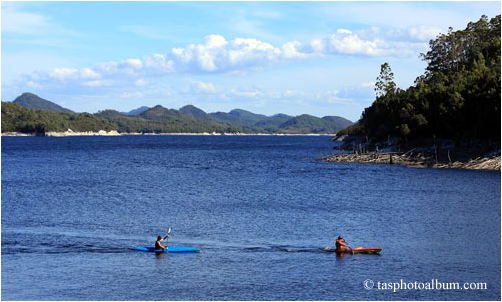
7/ The gentle waters of Lake Burbury are popular with boats and kayaks. This photo looks south. It was taken in the southern half of Lake Burbury.

8/ This photo looks towards the south of Lake Burbury.

9/ This view looks to the east and gives you some idea, as to how wide Lake Burbury is. I estimated that it was about 3 kilometres across at the widest points.

10/ This view looks across Lake Burbury to the west. The large peak in the centre is Mount Owen, which is 1146 metres high. Beyond Mount Owen is Queenstown.

11/ This photo was taken from the western side of Lake Burbury and looks to the west. Beyond these peaks is Queenstown. Note the fields of button grass in the field to the left of the photo.

1/ A few kilometres east of Lake Burbury is the trail to Nelson Falls. The trail is well paved and it is only a short walk through a beautiful rain forest to reach the falls.

2/ This view shows the lovely rain forest of Nelson creek on the way to Nelson Falls.

3/ This photo shows the Nelson Falls. Unfortunately, that summer the water flow was quite low. I estimated that the fall was about 40 metres. I intend to return for a better photo in the winter, when it is much more impressive.

1/ Mt Jukes is a peak east of Queenstown in south western Tasmania. This gallery shows images made on a visit to Mt Jukes in 2014. This image shows Mt Jukes from Mt Jukes Road. The first part of our journey was a steep climb starting from this position on Mount Jukes Road.

2/ This images shows our group ascending Mt Jukes. There was no track. We were simply following a route known to the walking clubs.

3/ This image shows the steep mountain face that we were climbing. The pink hue is probably caused by copper ore, which is very widespread in this area.

4/ Here you can see us approaching the summit of Mt Jukes. At this stage we were scrambling up over rocks. Climbing Mt Jukes is only for experienced groups of walkers.

5/ This image shows clearly the both the pink hue of the mountain side and how steep most of the cliffs were. Hard as our route was, it was the only way that Mt Jukes could be conquered.

6/ We were now so high that we could catch glimpses of a distant Lake Burbury. We would be following the spur line of this mountain, that you can see, to our exit point.

7/ At this point we could see far beyond Lake Burbury to the mountains of the east.

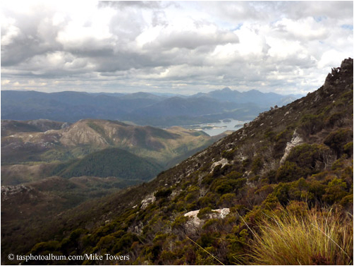
8/ This view was taken from near the summit and shows the view looking south towards the peaks of the West Coast Range. Note how sparse clumps of vegetation were managing to survive on this bleak plateau. It was a very interesting place.

9/ This image shows a fuller view of Lake Burbury. The old town of Crotty is submerged beneath the water at this point. The road is Mount Jukes Road, our exit point from this mountain visit.
10/ Mt Jukes trig point is 1162 metres high. Reaching it is quite an achievement. This image shows the view to the north of Mt Jukes.

11/ This view is looking south from the summit of Mt Jukes at the many peaks of the South Coast Range. We would now be heading in this direction.

12/ To exit we now followed the spur of the mountain, which went towards the south east. It was sparsely covered by vegetation, as is common on the tops of mountains in Tasmania. The shadow that you can see was being cast by Mt Jukes.

13/ This image shows more of the plateau on the spur of the mountain that we were traversing.

14/ From this point we got another magnificent view to the east of Lake Burbury.

15/ We were wending our way to a point where the mountain could be relatively easily exited. I noticed how the view can change quite suddenly, when you are walking along a mountain spur.

16/ This image shows a distant Mt Huxley under a cloud. Despite it being summer there were still some unmelted clumps of snow.

17/ This image shows another view from the spur to the mountains to the east.

18/ Finally we reached a point where we could descend from the mountain.

19/ Finally towards the evening, we reached Mt Jukes Road. This image shows Mt Jukes Road looking north towards Mt Huxley, which you can see in the next gallery.

1/ Mt Huxley is a peak in south western Tasmania east of Queenstown. It is just north of Mt Jukes. This image shows our group approaching Mt Huxley from the northern side, where there is a track to the summit. This track connects with Mt Jukes Road.

2/ The track is just a defined trail and it involves a lot of scrambling over rocks. Note the pink hue of the rocks, which is common in this area.

3/ I was impressed by the geology of the mountain. These huge, stark rocks have been sculptured by the wind and show horizontal layers, which have since been tilted.

4/ This image shows the rocky terrain that we were ascending through. This gap shows the vast forests to the west of Mt Huxley.

5/ At last we reached the summit, where there is this viewing platform. Beyond us to the east was the large Lake Burbury.

6/ When we looked to the south from the summit, we could see Mt Jukes and Mt Jukes Road. Mt Jukes is shown in the previous gallery.

7/ When we looked to the north from Mt Huxley we could see Mt Owen. You can visit this mountain in the next gallery. To the right is Lake Burbury. This huge lake is about 20 kilometres long.

8/ This image continues the view to the east. It shows the mountains surrounding Lake Burbury.
9/ This view shows the north eastern side of Mt Huxley, as we descended the mountain.

10/ This image shows Mt Owen to our north in the light of the late afternoon. It was being shaded by heavy clouds. This image was taken from the The Mt Huxley Track at ground level.

11/ This is an evening view of Mt Huxley and beyond it is Mt Jukes. It shows the exotic colours and shapes that you regularly see in the wilderness of Tasmania.

1/ Mt Owen is a peak east of Queenstown in south western Tasmania. It has been heavily damaged by deforestation and the sulphur fumes from the nearby Mt Lyell copper mine. This image shows the view up its stark, rocky face.

2/ We approached Mt Owen from a point on the A10 Lyell Highway west of the mountain. This image shows the view back to the Lyell Highway, as we began our ascent.

3/ This is Horsetail Falls. It is on the south western face of Mt Owen. In some areas there has been some regrowth. We were now climbing in a south easterly direction up the western face of Mt Owen.

4/ This image shows our group further up the south western face of Mt Owen from above Horsetail Falls. Note how the regrowth is very uneven depending on how damaged the area was.

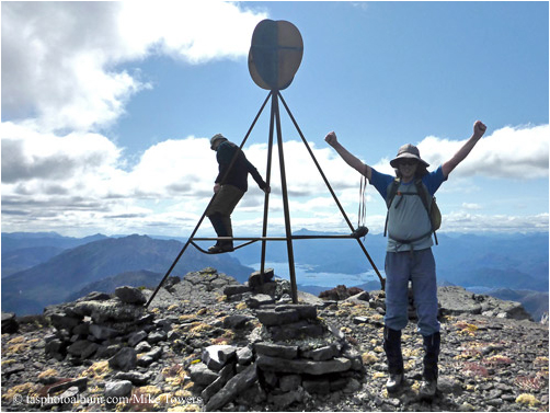
5/ This image looks straight up Mt Owen to the communications tower at the top. This was the final objective of our trek.

6/ This image shows the stark rocky cliffs that make up much of Mt Owen. If you compare this to the vegetation cover on nearby mounts Jukes and Huxley, you get some idea of how much damage was done by the copper mine.

7/ This image shows the strange sculptured shapes made by the erosion of this mountain.

8/ Finally we reached the summit and we could behold this view of Queenstown to our west.

9/ This view looks to the north west and shows the northern part of Queenstown.

10/ This view shows how desolate is the summit of Mount Owen.

11/ This view is looking south towards Mt Huxley. The barrier that you see is there to help prevent further erosion and aid the regrowth.

12/ This view shows the rough road that goes to the communications tower on the summit of Mt Owen. We would be descending down this road.

13/ Mt Owen is 1146 metres high. This image looks to the east towards Lake Burbury.

14/ This image shows the full panoramic view that you can see of Lake Burbury.

15/ This view shows the north eastern view of Lake Burbury.

16/ This image shows the exposed rock of Mt Owen. I am not a geologist, but I think that he pink colour indicates that copper ore is present.

17/ This image looks back at the communications tower as we descended.

18/ This is the rough road that goes up hill to the communications tower on the summit.

19/ This image looks down to the north on the former town of Gormanston. This was once a large mining town, but today most of the houses are gone.

20/ This image shows the view of the desolate landscape seen down at the lower level. A slither of Queenstown is showing over the hill.

1/ Mt Sedgwick is in south western Tasmania east of Queenstown. There is a on the south western side of the mountain. This image shows Mt Sedgwick looking at its southern face. This gallery shows photos made on a visit to Mt Sedgwick in 2014.

2/ Our trek began in the early morning on the track on the southern face. This image shows us walking north towards Mt Sedgwick. Mt Lyell is to the south of us beyond the low lying cloud.

3/ We had to cross a mountain stream. This image shows a trekker using his poles to guide him.

4/ As we ascended Mt Sedgwick a panorama open up to us. This image is looking south towards Mt Lyell. Lake Burbury is on the distant left.

5/ We had now reached the spur line, which we would follow north west to Mt Sedgwick.

6/ This image shows us approaching the rocky summit of Mt Sedgwick.

7/ From the summit of Mt Sedgwick there is a vast panoramic view. This image from the summit is looking south at Mt Lyell.

8/ This image from the summit of Mt Sedgwick is looking south east towards Lake Burbury. Mount Lyell is on the right of the image.

9/ This image is looking north west towards Lake Margaret and Mt Geikie. The small lake in the middle is Lake Bamadas.

10/ This image from the trig point is looking north east towards Lake Spicer. Note the large number of small tarns on the plateau. They testify to how wet it is at this level.

11/ This image from the trig point is looking north east towards Lake Spicer. Note the large number of small tarns on the plateau. They testify to how wet it is at this level.

12/ This image was taken on the return journey. It is looking at Mt Sedgwick from the south east and it shows the types of vegetation that you meet on the plateau.

13/ This image was taken on the track home. It gives you some idea as to how steep are the slopes of Mt Sedgwick on the southern face.

1/ Walford Peak is in south western Tasmania. This gallery shows photos made on a trip to this area in 2014. The trip began at Lake Plimsoll. This can be reached on the B28 Anthony Road. We began by ascending Julia Peak, where we beheld this magnificent view of Lake Plimsoll to our north east.

2/ This image was taken from Julia Peak and is looking south east at the Lake Spicer Track and a distant Lake Rolleston. After we descended Julia Peak, we followed this track to the south east.

3/ This photo shows the view to the south. On the right is Newton Peak and the Tyndall Range. Wisps of clouds were punctuating our view.

4/ We then trekked to the south east on the Lake Spicer Track. This photo shows our group looking at a distant Walford Peak.

5/ This image shows the view on the Lake Spicer Track closer to Walford Peak.

6/ This image shows the landscape near Walford Peak. It was a classic glacial valley. The many large rocks were deposited here by an ancient glacier. The weather was overcast, but we were fortunate to be given bursts of sunlight, as you can see in this image.

7/ We were surrounded by mysterious mountains made even more exotic by the dark sky and the low lying clouds. This landscape was punctuated by bursts of sunlight.

8/ This image shows the strange zones of vegetation that divide this area.

9/ These giant boulders were deposited here by an ancient glacier.

10/ This image shows a late afternoon view of a distant Lake Plimsoll. We returned to it at the end of our trip into the wilderness.

