

.

.


Main photo gallerys are below Information.
BRIDPORT
East Sandy Point & Barnbougle Dunes
SMALL PHOTO & INFORMATION PAGE
BRIDPORT is a modern, beach town with many facilities. It is the largest town east of George Town in the north east of Tasmania and there is much accommodation in this area. Just east of Bridport is the world famous BARNBOUGLE DUNES Golf Course, plus its airfield and beach. This is on the eastern edge of the town. Bridport is the place where Tasmanian families come to have a holiday. It is located north east of LAUNCESTON.
From Bridport you are 15 minutes from SCOTTSDALE, 30 minutes from the BRIDESTOWE LAVENDER farm, as well as WEYMOUTH, WATERHOUSE and GEORGE TOWN. You are 60 minutes from LAUNCESTON, MUSSELROE BAY, DERBY and ANSONS BAY. Nearby places are described in the NORTH EAST REGION page.
There is a shopping precinct at Bridport. There is also a restaurant and tourist shop at the Barnbougle Dunes Golf Course. There is much accommodation in BRIDPORT.
TOURIST information is at the PAVILION INFORMATION & CRAFT CENTRE, Main St, Bridport. Telephone (03) 6356 1881
SIGHTS: Bridport is a small coastal town famous for its beaches. It is on the estuary of the Brid and Forester rivers, which feed into Anderson Bay. It is a popular beach holiday venue for Tasmanians. The attractions include the:
-
BARNBOUGLE DUNES Golf Course is just east of the town.
-
WILDFLOWER Reserve is just north of the town.
-
EAST SANDY POINT Reserve with its beautiful dunes and beaches is a short drive north west of Bridport.
-
BRIDPORT FORESHORE has a great seaside walk.
ROUTES: From LAUNCESTON drive north on the A8 East Tamar Highway to just south of GEORGE TOWN, where you turn east onto B82 Bridport Road.
From SCOTTSDALE you drive north east on B84 Bridport Road.
SCOTTSDALE is on the main EAST COAST access road, the A3 Tasman Highway, which connects LAUNCESTON to the east coast.
To LARGER BRIDPORT PHOTOS
- BRIDPORT
- East Sandy Point
- Barnbougle Dunes

1/ Bridport is on the north east coast of Tasmania. It is a modern town that caters for the many Tasmanians, who come to its beautiful beaches.

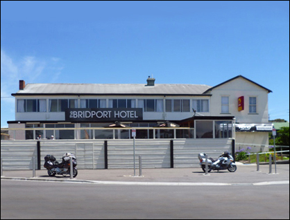
2/ The Bridport Hotel has a grand view of the beaches and the modern town.

3/ The Village Green at Bridport has play equipment for children.

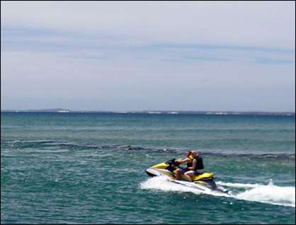
4/ The boat ramp on the Forester River Estuary is here being used by jet skis. Bridport is to the right.

5/ A jet ski speeds out of the mouth of the Forester River.
6/ West of the estuary at Bridport are the beautiful white sands of Goftons beach.

7/ Goftons Beach is also used by fishermen. It is one of a number of beautiful beaches at Bridport.

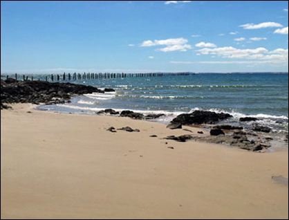
8/ This view is looking east across the Forester River mouth at Bridport. On the other side of the river is the Barnbougle Dunes Golf Course. Beyond is Anderson Bay.

9/ This view is looking down the Forester River towards Bridport jetty. Across the river is the famous Barnbougle Beach, which is now home to the famous golf course.

10/ Bridport was once primarily a port for the fishing industry. Seen here is the Southern Condor, one of the ferry boats that cross to Flinders Island.

11/ This green barge is also one of the Flinders Island ferries that moor at Bridport. It is used to transport cattle.

12/ This rusty old trawler shows that Bridport was once an important fishing port.

13/ This pier on the Brid River is used by the numerous small pleasure boats of Bridport.

14/ This is a view of the small beach near the Caravan Park at Pier Point, west of Bridport.

15/ This is another view of the small beach near Pier Point. Bridport is to the right.

16/ This is the ancient collapsed pier at Pier Point.

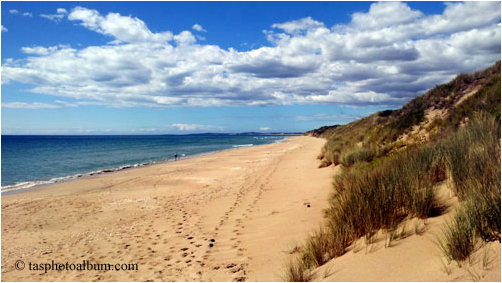
1/ East Sandy Point is a lovely, deserted peninsula in north eastern Tasmania. It is east of Bridport. This area is accessed from Sandy Point Road, which travels west out of Bridport. This gallery shows images taken on a club excursion in the summer of 2014. This image looks to the east of Lodes Beach.

2/ A rough track leads from the end of the Sandy Point Road to Lodes Beach. On this occasion a hazard warning was placed on the road to stop drivers continuing. You would be most foolish to attempt to wade this stream either on foot or in a car. It is much more dangerous, than it looks.

3/ This image shows the final approach over a dune to Lodes Beach. This kind of track is only suitable for AWD vehicles.

4/ We found this interesting, amateur, tree sculpture on Lodes Beach near an area of the beach that was used by juvenile delinquents or "car hoons", as they are called in Tasmania.

5/ This image looks south east down Lodes Beach. The sign warns visitor to care for the shore birds that nest in this area.

6/ This stretch of Lodes Beach looks to the north west towards the Double Sandy Point Reserve. The circular patterns in the sand were recently made my juvenile delinquents or "car hoons". They call this "doing wheelies". Tasmania would be one of the few places in the world, where great beaches are available for doing car driving pranks.

7/ This image shows a rock platform near Double Sandy Point Reserve. It looks towards the north west.

8/ This image shows the view from near Sandy Point. It looks across Anderson Bay.

9/ The Double Sandy Point Reserve has many massive moving sand dunes. This image shows our group climbing a large dune.

1/ Barnbougle Dunes is a world famous golf course on the eastern edge of Bridport. This photo is looking west from the Lost Farm Restaurant towards Bridport, which is on the distant right horizon. Just beyond the dunes on the right is Barnbougle Beach.

2/ This is the view of the Barnbougle Dunes Golf Course to the south of the Lost Farm Restaurant. The course is many kilometres in size

3/ From the Barnbougle Dunes Golf Course you can walk straight under the dunes to Barnbougle Beach. This is the view to the west looking towards Bridport.
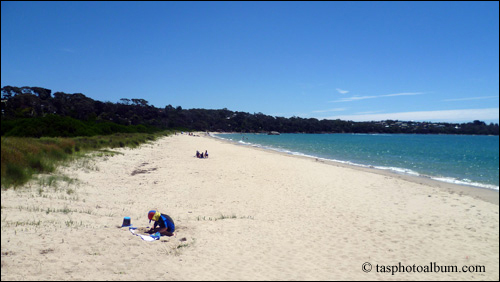
4/ This is the lovely view from Barnbougle Beach looking towards the Waterhouse Conservation Area in the east. It is like the other long, beautiful, beaches of Bridport.

